
A strange shift high above the Arctic is capturing the attention of meteorologists around the world. As winter deepens, atmospheric signals suggest that the polar vortex—the massive ring of cold air that normally stays locked over the North Pole—may be heading toward a disruption.
Forecast models and satellite data are showing unusual patterns in the upper atmosphere. Temperatures are rising where deep cold usually dominates, and the winds circling the pole are beginning to wobble. Scientists say the signals are strong, but the exact outcome remains uncertain.

For now, one thing is clear: something unusual is unfolding over the Arctic that could reshape winter weather across large parts of the Northern Hemisphere.
Why the Polar Vortex Matters
The polar vortex is a huge circulation of cold air spinning high in the atmosphere above the Arctic. In a typical winter, it acts like a containment system, keeping the coldest air locked near the pole.
When the vortex is strong, weather patterns tend to remain relatively stable. But if it weakens or becomes distorted, that cold air can escape and surge southward.

That’s when unusual winter conditions begin to appear.
What Happens When the Vortex Weakens
A disrupted vortex can trigger dramatic shifts in the jet stream—the fast-moving river of air that guides storms across continents. Instead of flowing smoothly from west to east, the jet stream can develop large waves that push Arctic air deep into mid-latitude regions.
These swings can produce extreme cold outbreaks, heavy snowstorms, or sudden warm spells depending on where the displaced air settles.
The Role of Sudden Stratospheric Warming

One possible trigger for the current atmospheric instability is a phenomenon known as sudden stratospheric warming (SSW).
This event occurs when temperatures high in the stratosphere rapidly increase over the Arctic, sometimes by 30 to 50°C in just a few days. The warming disrupts the polar vortex, slowing its winds and occasionally splitting it into multiple pieces.
When this happens, the effects can cascade downward into the lower atmosphere weeks later—altering surface weather patterns across Europe, Asia, and North America.
Signs Scientists Are Watching
Meteorologists are now tracking several indicators that suggest the vortex may be under unusual pressure. Atmospheric waves rising from the lower atmosphere appear to be striking the vortex more aggressively than usual.
At the same time, satellite observations are detecting pockets of warming in the Arctic stratosphere.
The combination is raising questions about how February’s weather could evolve.
Key Differences Between Normal and Disrupted Winters
| Atmospheric Feature | Typical Winter Pattern | During Arctic Disruption |
|---|---|---|
| Polar Vortex | Strong and stable over the Arctic | Weakened, stretched, or split |
| Jet Stream | Relatively straight west-to-east flow | Wavy pattern with deep north–south dips |
| Cold Air Location | Confined mostly to polar regions | Pushed into mid-latitude continents |
| Surface Weather | Gradual and predictable changes | Sudden cold snaps, unusual snowstorms |
Why Scientists Are Struggling to Explain It
Although polar vortex disruptions have occurred before, this winter’s signals don’t neatly match previous patterns. Researchers say several factors may be complicating the situation.
Complex Atmospheric Interactions
Weather systems near the surface—storms, mountain ranges, and temperature contrasts—can send waves upward into the stratosphere. These waves can weaken the vortex, but the exact interactions vary from year to year.
Rapid Arctic Warming
The Arctic is warming significantly faster than the rest of the planet. Thinner sea ice, warmer oceans, and shifting snow cover are changing the background conditions that influence the polar vortex.
These changes may be altering how winter weather systems behave.
Limits of Forecast Models
Even advanced forecasting models have difficulty simulating how disturbances in the upper atmosphere translate into surface weather weeks later. That makes it difficult to predict exactly which regions will feel the strongest impacts.
What It Could Mean for February
If the vortex disruption strengthens, the effects may not appear immediately. Historically, changes in the stratosphere often take one to three weeks to influence weather closer to the ground.
That means the atmospheric shifts now being detected could shape the heart of winter rather than the immediate forecast.
Some regions could see intense cold and snow, while others may experience unusually mild conditions as weather patterns reorganize.
A Winter Pattern Still Unfolding
Meteorologists are continuing to monitor new data from satellites, weather balloons, and global forecast models as the situation develops.
While the exact outcome remains uncertain, the unusual activity above the Arctic is a reminder that the atmosphere is a complex and evolving system.
As February approaches, scientists will be watching closely to see whether the polar vortex stabilizes—or whether the developing disruption reshapes winter weather across the Northern Hemisphere.

  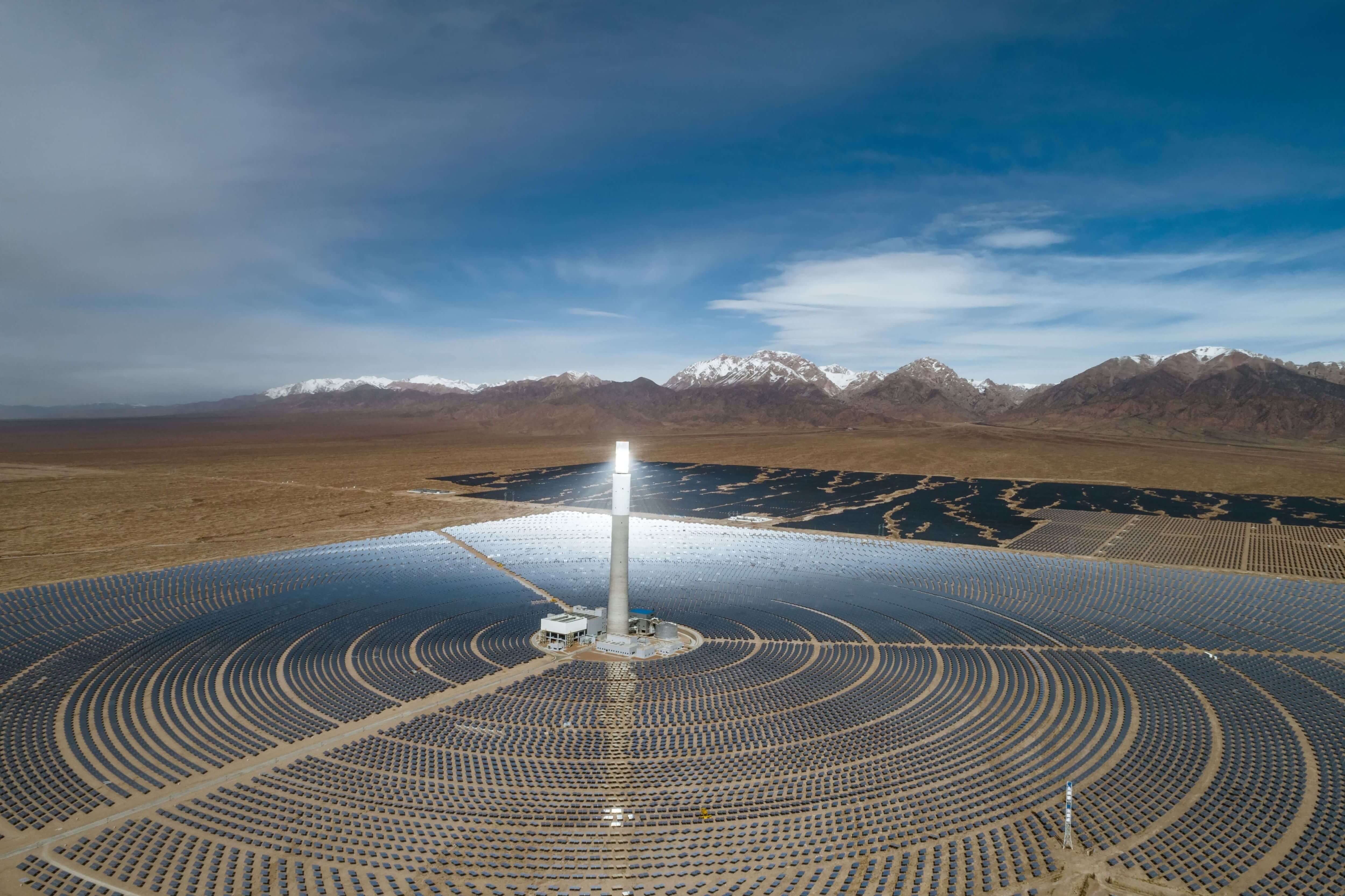 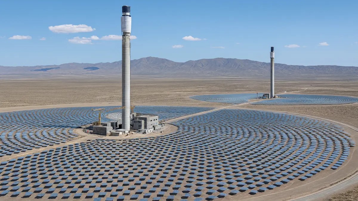 ## Scientists Are Building an “Artificial Sun” in the Desert — And It Could Change How Cities Get Power In a remote desert landscape, something extraordinary is taking shape. Thousands of mirrors stretch across the sand, reflecting sunlight toward a central tower that glows brighter than anything else in sight. Nearby, inside steel chambers and advanced laboratories, scientists are attempting something even more ambitious: recreating the energy process that powers the stars. Researchers and engineers have begun calling the project an **“artificial sun.”** The goal is simple but revolutionary — generate enormous amounts of clean electricity using the same fusion process that fuels the real sun. If successful, this technology could provide nearly unlimited energy for cities while dramatically reducing carbon emissions. ## What Is an Artificial Sun? The term “artificial sun” refers to **nuclear fusion reactors**, experimental machines designed to replicate the reaction happening inside stars. ### How fusion works In the core of the sun, hydrogen atoms collide under extreme heat and pressure. They fuse together to form helium, releasing massive amounts of energy. Scientists are trying to recreate that reaction on Earth. To do this, they: * Heat hydrogen fuel into plasma hotter than the sun’s core * Use powerful magnetic fields to hold the plasma in place * Trigger atomic fusion that releases energy If the process becomes stable and efficient, fusion could provide **clean, abundant electricity with minimal environmental impact.** ## Why the Desert Is the Perfect Location Fusion facilities and large solar energy complexes require huge amounts of space and sunlight. That’s why many experimental projects are being built in desert regions. ### Advantages of desert locations * Up to **300 sunny days per year** * Large open land areas for solar mirror fields * Low population density * Stable ground for heavy infrastructure The desert environment also allows researchers to combine fusion research with **concentrated solar power systems**, creating hybrid energy plants. ## The Role of Giant Mirror Fields One of the most striking features of the facility is the field of heliostats — massive mirrors that follow the sun across the sky. Each mirror reflects sunlight toward a central tower where heat is collected and stored. ### What heliostats do * Concentrate sunlight into extremely high temperatures * Produce steam that spins turbines * Store thermal energy in molten salt tanks * Generate electricity even after sunset This solar system provides immediate renewable power while supporting the experimental fusion infrastructure nearby. ## How the Artificial Sun Could Power Cities The long-term goal is to create power plants that operate around the clock without fossil fuels. Fusion could provide stable electricity regardless of weather conditions, solving one of the biggest challenges facing renewable energy today. ### Potential energy output Component | Purpose | Estimated Impact Solar mirror tower | Daytime renewable electricity | Up to 150,000 homes Fusion test reactors | Experimental constant power | ~50,000 homes in early phases Thermal storage tanks | Nighttime electricity supply | 4–6 hours grid backup Battery systems | Stabilize the grid | Instant response to demand spikes Although these numbers are still projections, the concept shows how multiple technologies could work together to power entire urban areas. ## Why Fusion Energy Is So Important Global electricity demand continues to grow as more systems move toward electrification — from vehicles to heating systems and data centers. Fusion energy offers several advantages compared with traditional power sources. ### Key benefits of fusion power * No greenhouse gas emissions during operation * Fuel derived from hydrogen, one of the most abundant elements * Minimal long-term radioactive waste * No risk of runaway chain reactions Because of these factors, fusion is often described as the **“holy grail of clean energy.”** ## The Biggest Challenges Scientists Still Face Despite decades of research, fusion remains one of the most difficult engineering challenges in modern science. Creating plasma hotter than the sun and controlling it inside a reactor requires incredibly precise technology. ### Major hurdles * Maintaining stable plasma for long periods * Designing materials that survive extreme heat * Scaling experimental reactors into commercial power plants * Reducing costs so electricity becomes affordable Scientists have made major breakthroughs recently, including successful experiments that produced **net energy gain for brief moments**. However, reliable commercial fusion power is still under development. ## Key Takeaways * Scientists are building experimental fusion reactors known as **artificial suns**. * These projects aim to generate massive amounts of clean electricity. * Desert locations provide ideal conditions for solar and fusion infrastructure. * Fusion could eventually deliver constant, low-carbon energy for cities worldwide. While the technology is still evolving, progress is accelerating as governments and private companies invest billions into fusion research. ## Frequently Asked Questions ### What is an artificial sun in energy research? An artificial sun is a nuclear fusion reactor designed to replicate the energy process that powers stars. ### Is fusion energy safer than nuclear power? Fusion generally produces less radioactive waste and cannot trigger runaway chain reactions like traditional nuclear fission plants. ### When will fusion power become widely available? Many experts expect early commercial fusion plants to appear between the **2030s and 2040s**, though timelines remain uncertain. ### Why are fusion experiments built in deserts? Deserts provide strong sunlight, large open land areas, and stable environments for building large energy facilities. ### Could fusion completely replace fossil fuels? Fusion could become a major clean energy source, but it will likely work alongside solar, wind, and other renewable technologies. ## Conclusion For decades, the idea of building a miniature star on Earth sounded like science fiction. Today, that vision is slowly becoming reality in remote deserts where scientists are testing the limits of physics and engineering. The artificial sun projects rising from the sand represent more than an experiment. They represent a new possibility for how humanity powers its future. If fusion energy succeeds, the lights in cities around the world may one day be powered by the same process that makes the stars shine.](https://ozpuff.com.au/wp-content/uploads/2026/03/Scientists-Are-Building-an-Artificial-Sun-in-the-Desert-—-And-It-Could-Change-How-Cities-Get-Power-1024x576.png)